Dispatches About Get the App
Robin Ulrich
Switzerland  ·  46.59°N 7.91°E

The Bernese Oberland

Written by Henry Whitlock  ·  20 June 2026

Five nights in the Lauterbrunnen valley, where seventy-two waterfalls fall from the cliffs and the railways climb to the roof of the Alps.


The valley arrived before I did. The train from Interlaken slips between two walls of rock, and the world narrows to a green floor, a thread of river, and cliffs so sheer they seem drawn rather than built. Somewhere above, a ribbon of water leaves the rim and falls so far it turns to mist before it lands. By the time we stepped down at Lauterbrunnen, the place had quietly rearranged what a landscape could be.

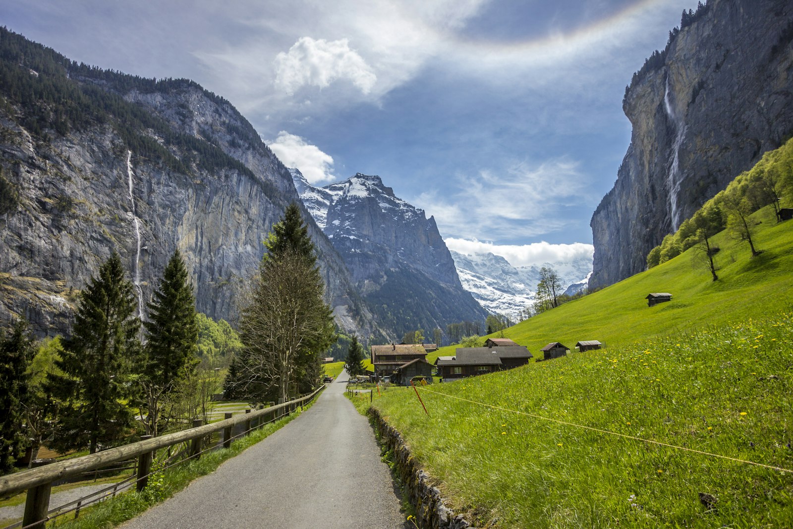
Seventy-two waterfalls, they say, come off these walls. I counted on the first afternoon and gave up somewhere in the teens, which is probably the honest number to arrive at. The famous one is the Staubbach, almost three hundred metres off a bare cliff in a single fall, thunderous in spring and, by August, barely there. Stand under it once, then stop looking at the named things and start noticing the rest: the small falls that only show after rain, the cowbells, the smell of cut grass and cold stone.

The Staubbach Falls dropping from a cliff into the Lauterbrunnen valley
The Staubbach, falling clear of the cliffLeo Visions

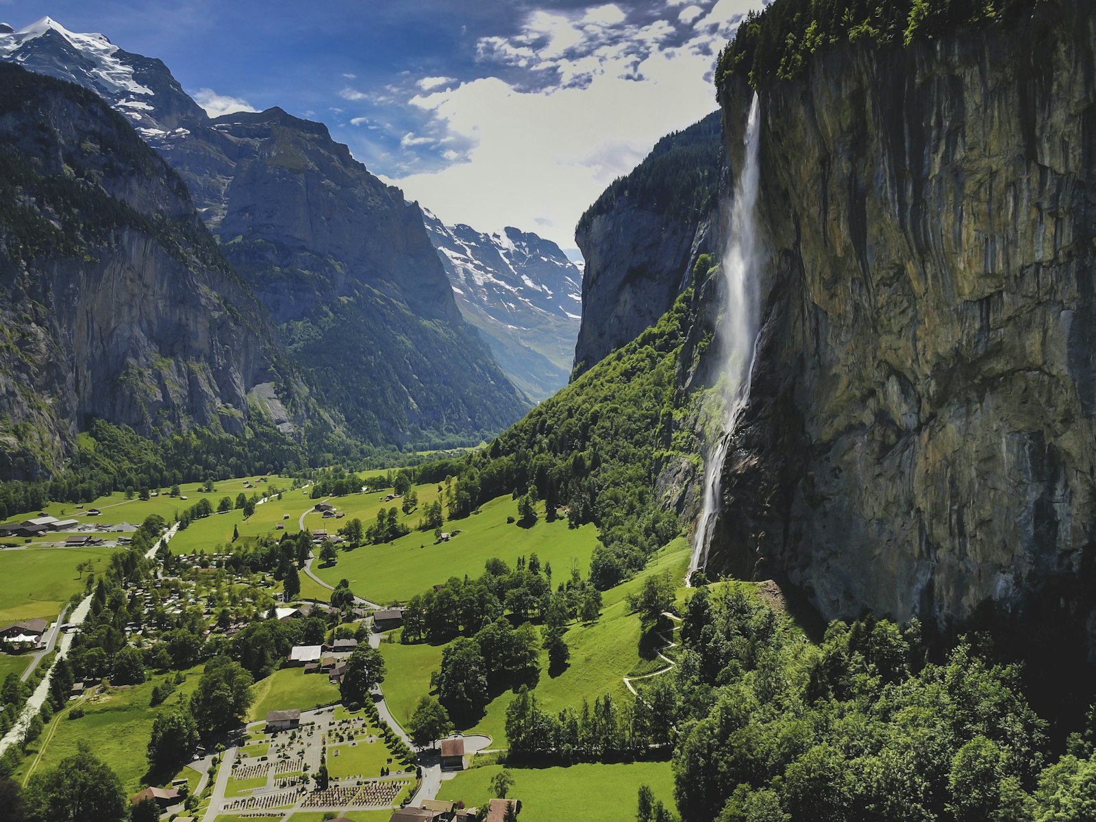
Lauterbrunnen makes the obvious base, and the first day belongs to the valley floor: flat, walkable and mostly free, which after the sticker shock of a Swiss coffee is its own kind of relief. The lane to Stechelberg runs past barns and meadows to the Trümmelbach, ten glacier-fed falls thundering through the rock itself, lit and laddered so you can climb up among them. Back out in the light, I did nothing in particular, which is the one thing the valley floor really asks of you.

A quiet lane through green meadows under the cliffs of the Lauterbrunnen valley
The valley floor, toward StechelbergMichael Lämmli

There is only one sensible way out of the valley, and that is straight up. No road reaches the villages on the western shelf, so a cable car hauls you out of Lauterbrunnen and a small train trundles the rest of the way to Mürren, a single street of dark timber hung above the drop. Across the gulf of air stand the three everyone comes for, the Eiger, the Mönch and the Jungfrau, close enough to read the weather off their faces. The sky held, so I carried on up: the cableway to the Schilthorn ends at a revolving terrace where the panorama runs to the horizon, and it turned me through a full circle twice before I quite believed it.

The car-free village of Murren on a shelf above the valley
Mürren, on its shelf above the valleyPatrick Federi
A red cog railway train below the Eiger and Monch
The cog railway, below the EigerPiotr Guzik

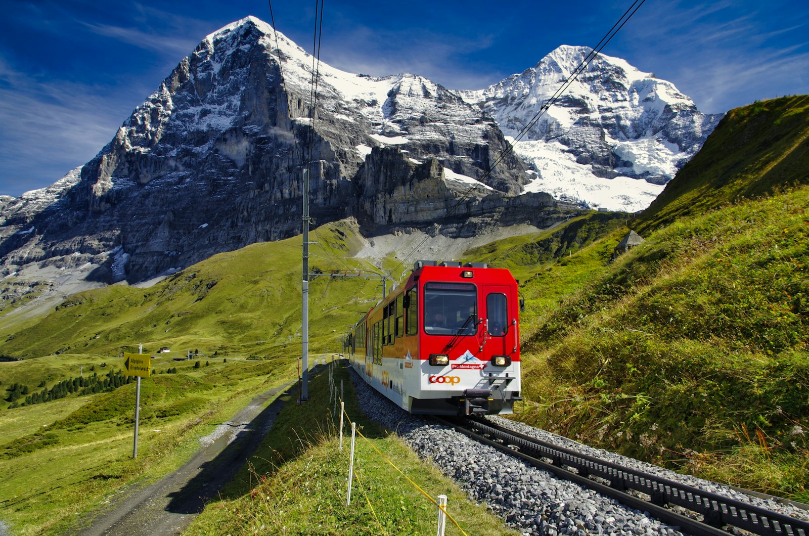
The third day belongs to the railway, because here the railway is the point. From the other shoulder of the valley, a cogwheel train climbs through Wengen to Kleine Scheidegg, a windswept saddle laid right at the foot of the Eiger's north face. This is where the lines meet, and where the most improbable of them begins: the Jungfrau Railway, bored straight up through the mountain in the early years of the last century, climbing in the dark to the highest station in Europe.

I did not conquer these mountains. I was lent a morning on them, and sent back down before the cloud came in.


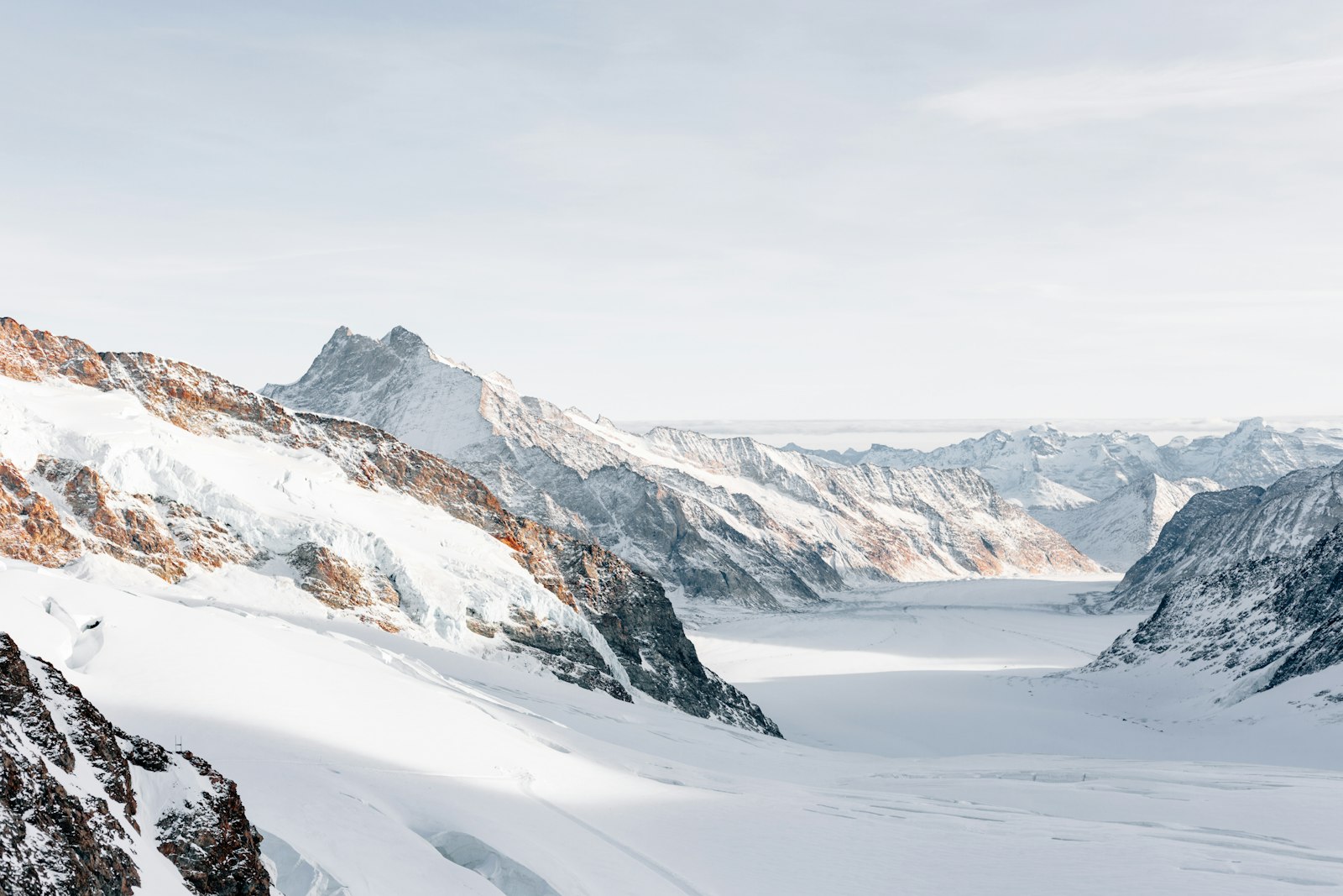
The train surfaces at the Jungfraujoch onto a different planet: thin air, hard light, and the long white tongue of the Aletsch, the largest glacier in the Alps, curving away below as if the whole range had been poured and frozen. Go early. The summit makes its own weather, and the clear nine o'clock I was given was a whiteout by noon. There is no rushing a place like this. You stand still, breathe the thin air slowly, and let the scale of it land.

The Aletsch glacier and snowfields seen from the Jungfraujoch
The Aletsch, from the JungfraujochErol Ahmed

The last evening belongs back down in the green. After the glare of the snow the valley feels almost tropical, loud with water and warm with hay. We ate early and walked the lane while the cliffs went gold and then violet, the Staubbach still falling somewhere in the dark. Five nights is enough to learn the shape of the place, and nowhere near enough to leave it willingly.

Plan a similar trip

My itinerary

Fly into Zürich, under three hours to Lauterbrunnen via Interlaken Ost. Base five nights at the Hotel Silberhorn, ride everything on a Jungfrau Travel Pass, and go June to September.

  1. Day 1

    Into the valley

    Drop the bags and walk the flat valley floor, out to Stechelberg and the Trümmelbach falls inside the cliff.

    Travel

    Interlaken Ost to Lauterbrunnen, about 20 minutes

  2. Day 2

    Up onto the shelf

    Up to car-free Mürren on its ledge, then the cableway to the Schilthorn's revolving terrace for the full ring of peaks.

    Travel

    Cable car and train to Mürren, then the Schilthorn cableway up top

    The valley cable car can close for spring maintenance; the Stechelberg cableway is the backup.

  3. Day 3

    The great rail climb

    Cogwheel trains climb past the Eiger to Kleine Scheidegg, then bore up through the mountain to the highest station in Europe.

    Travel

    Lauterbrunnen to Kleine Scheidegg, then the Jungfraubahn to the top

    Go on a clear morning, and reserve the summit train in summer.

  4. Day 4

    A day on foot

    The easy ridge from Männlichen to Kleine Scheidegg, the Eiger, Mönch and Jungfrau in view the whole way.

    Travel

    Train to Wengen, cable car to Männlichen, then walk, about 4.7 km

    The Männlichen lift and this trail are summer-season only.

  5. Day 5

    Down to green, and out

    A soft last morning under the Staubbach and a coffee in the sun, then the branch line back to Interlaken and on.

    Onward

    Lauterbrunnen to Interlaken Ost, then Zürich about 2h40

    Tempted to wake above the cloud? Swap a night up to Hotel Eiger in Mürren.

← All dispatches
Keep exploring

More dispatches

Meridian Dispatch for iPhone

A travel journal that
writes itself.

Your best memories, journaled automatically, from the photos already on your phone. The app reads your photo library, finds the international trips you have taken, identifies the venues, writes the prose, and lays it out like a magazine spread. The first time you open it, the last several years of your travel are already there. Every trip after that goes in by itself.

  1. Mapped on a globe

    Your whole world, on one globe.

    Every country you've visited, lit on a private 3D globe. Spin it to find a trip and fall straight back into it. The globe is the table of contents for your journal.

    The app's private globe of visited countries.
  2. Detected automatically

    It finds your trips on its own.

    Your photos cluster by place and time, and each cluster becomes a venue: the museum you spent the morning in, the restaurant you lingered over, the streets you wandered after dinner. No tagging, no prompts, no logbook to keep up.

    The app's archive, every trip a dispatch.
  3. In warm prose

    Each place, written up.

    Every day opens on a hero photograph, and each place you stopped gets its own short entry beside your own photographs, no two days laid out the same. A record of where you've been, kept in real sentences. Edit a line, or regenerate any passage you want fresh.

    A written day in the app, with a place entry and a photo grid.
  4. Yours to keep

    Every trip, as a photobook.

    Download any journal as a clean photobook, send it to whoever was there, or have it printed as a hardback you keep on the shelf. What you read on your phone is exactly what lands on the page.

    The app exporting a trip as a photobook, with Share PDF and Save to Files.