Globe Countries Cities Itineraries World's Best Hotels Events Login
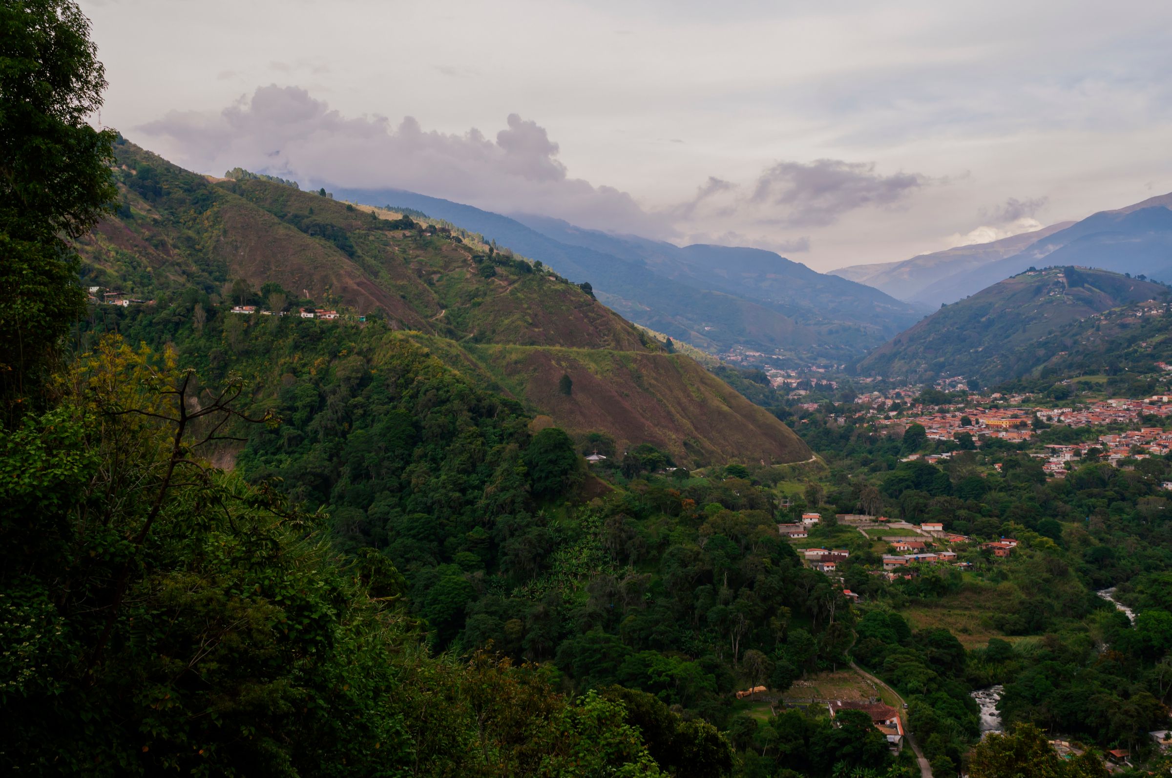
A green Andean valley with a red-roofed town spread along the valley floor, forested slopes on either side and blue ridges behind under cloud
A valley in the Mérida Andes · the Trans-Andean road climbs from valleys like this to over 4,000 m
Town brief · 8.5976°N 71.1443°W

Mérida

Make central Mérida your base and a morning's drive takes you up onto the páramo, the treeless moorland above about 3,000 m, to glacial lakes and the highest paved pass in Venezuela, with the city's squares and posadas to come back to by evening.

View on globe

Why you should go

Ninety seconds on Mérida

How long
Three nightstwo mornings up high and a day in the city
Getting around
On foot, then taxis and busesbuses to the páramo leave the city terminal
When
December to Marchthe dry months; heavy rain from April to November
Language
Spanishthe official language of Venezuela
Money
US dollars, in cashATMs and card terminals are unreliable
Airports
El Vigía VIGMérida's own airport, MRD, has few or no flights
How long

How many days do you need in Mérida?

Three nights cover the basics: one morning on the cable car, one on the páramo road to Laguna de Mucubají and Pico El Águila, and a day for the centre and the botanical garden. A trip to Los Nevados adds two days with a night in the village. Climbing Pico Bolívar takes several more days.

Getting around

How do you get around Mérida and out to the páramo?

The centre is walkable, pre-booked taxis cover short trips, and city buses run from about 5:00 to 19:30. Buses to Valera, Barinas and the páramo towns leave the Terminal José Antonio Paredes every 30 to 60 minutes from 6:00 to 17:00. Beyond El Morro, the road to Los Nevados is unpaved and suited only to 4x4 vehicles and experienced drivers.

When

When is the best time to visit Mérida?

December to March, the dry months. Heavy rain falls from April to November, and snow fell at the top station in September 2026, so pack for freezing cold. The Feria del Sol fills the city every February; book rooms well ahead for it, for Holy Week and for August. Cable car hours are extended in some holiday periods.

Language

What language is spoken in Mérida?

Spanish, the official language of Venezuela, which also recognises numerous indigenous languages.

Money

What currency is used in Mérida?

The bolívar is the official currency, but most prices are set in US dollars at the central bank's daily rate, and dollar cash is the everyday standard; paying in cash dollars can earn a discount. Many ATMs are out of order, and those that work give small bolívar notes. Bring dollar cash for the whole stay, in small notes. Shops ask for a passport before taking a credit card.

Airports

Which airport do you fly into for Mérida?

El Vigía, VIG, in Mérida state, which has domestic flights from Caracas; the bus or taxi on to Mérida takes one to two hours depending on the road. Mérida's own airport, Alberto Carnevalli, MRD, has little or no scheduled service, so check before booking. The main Caracas airport reopened in September 2026 with reduced capacity, and the direct bus from Caracas takes about 14 hours. Arrange a pre-booked transfer for any arrival after dark.

Plan a morning around the Mukumbarí cable car from Plaza Las Heroínas. In late September 2026 it ran Thursday to Sunday, with tickets sold at the ticket office in bolívares, and ascents to the upper stations ended in the early afternoon. Take the first cars of the day.

The ride lifts you more than three thousand metres in a few hours, so step out slowly at each station, drink water steadily and go back down if a headache or nausea sets in. Spend a night or two in the city before sleeping up on the páramo.

Give the next morning to the Trans-Andean road, which climbs north-east past Mucuchíes and the stone chapel at San Rafael to Apartaderos. There one branch rises to Pico El Águila and the other passes Laguna de Mucubají. To stop where you like, have your posada book a taxi for the day.

Rooms in the centre near Plaza Bolívar put the cable car, the tour agencies on Plaza Las Heroínas and most sights within a walk; ask for one off the main road, where traffic runs all night. Use pre-booked taxis only and avoid travelling after dark.

The UK Foreign Office advises against all but essential travel to Venezuela, Mérida included, and against all travel within 40 km of the land borders and parts of the south and east. The US rates the country Level 3, reconsider travel. Shops in the city reported daily power cuts of six to eight hours in September 2026, so carry a torch and a power bank.

Things to do

13
  1. Capilla de Piedra de San Rafael de Mucuchíes

    Church · 30 min

    Built from local stone without mortar by Juan Félix Sánchez, this chapel stands in San Rafael de Mucuchíes on the Trans-Andean road beyond Mucuchíes. Three arches on two levels hold its bells, and pieces of coral and shell are set into the walls. Half an hour covers it on the way up to the lakes.

  2. Jají

    Village · 4 hr

    Buses from the city terminal take one to two hours to this village 34 km from Mérida, at about 1,800 m. One large square plaza sits at its centre, ringed by houses of one and two storeys, with the plain, thick-walled church of San Miguel Arcángel and its three big doors. Allow about four hours with the bus there and back.

  3. Jardín Botánico

    Garden · 1.5 hr

    Forty-four hectares of gardens run by the Universidad de Los Andes sit beside the university athletics track at La Hechicera, on the north side of the city. The garden keeps daytime hours and is open all year. Allow an hour or two, which suits an afternoon after a morning up high.

  4. Laguna de Mucubají

    Lake · 2 hr

    A glacial lake at about 3,600 m, Laguna de Mucubají lies a kilometre off the Trans-Andean road beyond Apartaderos, with a road for cars down to the shore. Horses can be hired here with a local guide, and trails lead on to Laguna Negra and Pico Mifes. Allow an hour at the shore, or a morning with the walk to Laguna Negra.

  5. Laguna Negra

    Lake · 4 hr

    From the shore of Laguna de Mucubají, a trail leads to this dark lake about 150 m lower, and the walk there and back fills a morning at an easy pace. The same path continues toward Pico Mucuñuque. Start at the Mucubají shore, off the Trans-Andean road, with water and boots that can take mud.

  6. Los Nevados

    Village · 8 hr

    Jeeps leave Plaza Las Heroínas in the morning for this village of posadas at around 2,700 m, about four hours on a narrow dirt road. The other way in runs from the cable car's Loma Redonda station by mule or on foot, then down an old stone trail, once the cable car reaches that station and the mules are running. Posadas serve dinner and breakfast, so plan on a night.

  7. Mérida Cable Car

    Cableway · 5 hr

    The Mukumbarí runs 12.5 km through five stations, from Barinitas on Plaza Las Heroínas to Pico Espejo at 4,765 m, among the highest and longest cable cars anywhere. Pico Espejo has been reported closed for maintenance since the line reopened in August 2026, so ask at the Barinitas ticket office which stations are running. Ride early, as the top is usually in cloud by afternoon.

  8. Observatorio Astronómico Nacional de Llano del Hato

    Landmark · 2 hr

    Above the village of Llano del Hato, near Apartaderos and about 60 km by road from the city, the country's main observatory stands at around 3,600 m. A museum and exhibition centre explain its work. Public visits have run Thursday to Saturday from three to seven in the afternoon, and on holidays, so confirm before driving up and bring a warm layer.

  9. Pico Bolívar

    Mountain · 8 hr

    Venezuela's highest summit, at 4,978 m, rises above the city with a bronze bust of Simón Bolívar on top. The final pitch is a short rock climb on rope, harness and helmet, and the ascent is made with a guide after several days of acclimatisation. INPARQUES requires climbers to register a risk form, their route and schedule, and rangers inspect the equipment.

  10. Pico El Águila

    Viewpoint · 1 hr

    Cars pull in at 4,118 m, the highest point of the Trans-Andean road, on the pass also called Collado del Cóndor. A stone condor monument and the small Virgen de Coromoto chapel stand beside the road from Apartaderos toward Valera. Walk slowly in the thin air, and allow about an hour for the stop.

  11. Pico Mifes

    Viewpoint · 8 hr

    A trail of about 6 km climbs from the shore of Laguna de Mucubají over sandy ground to this summit of about 4,630 m. The walk takes a full day at altitude, and a first night beside the lake makes it easier. Set off with water, food and rain gear, and turn back if the weather closes in.

  12. Plaza Bolívar

    Landmark · 30 min

    The cathedral faces this square at the centre of the old grid, between avenues 3 and 4 and streets 22 and 23. Around it stand the archbishop palace, the state government palace and the rectorate of the Universidad de Los Andes, with the archaeological museum close by. The cable car base on Plaza Las Heroínas is under a kilometre's walk away.

  13. Sierra Nevada National Park

    Park · 8 hr

    Venezuela's highest peaks, Pico Bolívar and Pico Humboldt among them, lie inside this park, along with the páramo and glacial lakes of the Sierra Nevada de Mérida. The cable car, Laguna de Mucubají and the trail down to Los Nevados are the usual ways in. The park closed for a spell after the June 2026 earthquakes, so check with INPARQUES before a trek, and pack for nights below freezing.
Basemap Meridian · data © OpenStreetMap
Explore

More of Venezuela

Gran Roque
Town

Gran Roque

Canaima
Town

Canaima

A camp and Pemon village on a lagoon in the Gran Sabana, reached only by air, sits at the northern gate of Canaima National Park.

Sources 4

The official pages this guide was checked against.

Last updated