Globe Countries Cities Dispatches World's Best Events Get the App
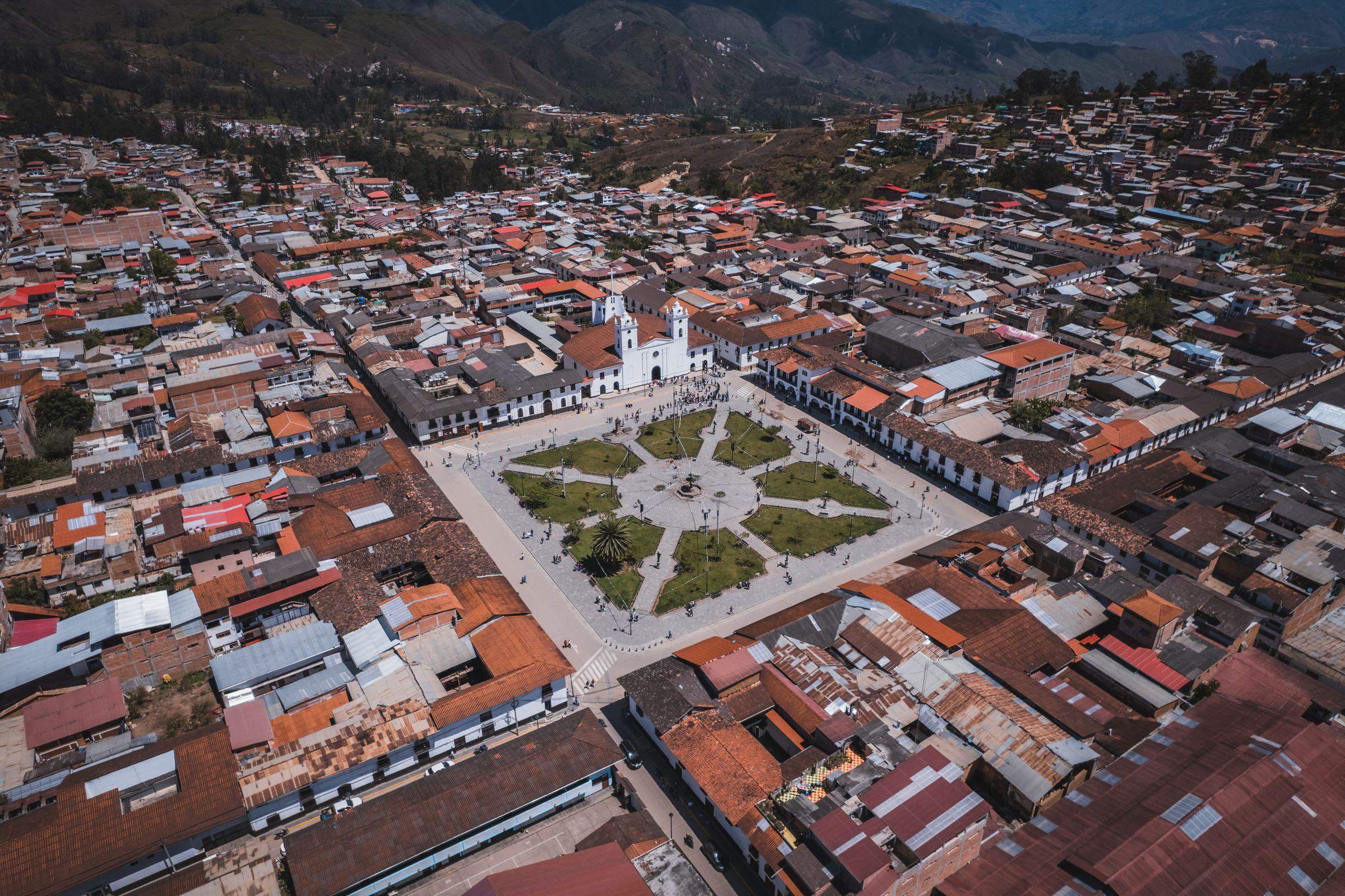
An aerial photograph of the Plaza de Armas in Chachapoyas, its gardens and the white cathedral, surrounded by red-tiled and tin roofs, with green hills behind
The Plaza de Armas from above · the town averages about 18°C through the year
Town brief · 6.2294°S 77.8694°W

Chachapoyas

Book your Kuélap ticket before your room: entry is capped each day and checked against your passport, so the day you can get decides how many nights you need here.

View on globe

Why you should go

Ninety seconds on Chachapoyas

How long
A base for day tripseach big site is a day out and back
Getting around
Tours, vans and taxisa taxi reaches the Sonche canyon in twenty minutes
When
May to Septemberthe dry months, best for the trails
Language
SpanishPeru's main official language
Money
Peruvian sol, in cashATMs are few, and some run dry
Airports
Chachapoyas CHHTarapoto TPP is about eight hours by road
How long

How many days do you need in Chachapoyas?

At least three full days, one each for Kuélap, Gocta and Karajía. Revash and the Leimebamba museum, 74 km to the south, make a fourth day for those with time.

Getting around

Is it better to take a tour or go by colectivo?

Kuélap works without a tour: vans leave the terminal for Nuevo Tingo, about an hour away, and the cable car runs from there. Vans to Cocachimba for Gocta are not direct and change at Pedro Ruiz, so a tour or a taxi is simpler, with the ride back arranged before the walk. Transport south to Leimebamba runs rarely, which makes a tour the practical way to Revash and the museum.

When

When is the best time to visit Chachapoyas?

May to September, the dry months, when the trails are firmest; the rains run from late October to April, and February and March are the wettest. Gocta flows all year and is at its best from April to June, when the falls still run strong and the trail has dried out. The first week of June is Tourist Week, which ends in a Sunday parade of villages from across Amazonas.

Language

What language is spoken in Chachapoyas?

Spanish. A local variety of Quechua is also spoken in the Chachapoyas and Luya provinces.

Money

What currency does Chachapoyas use, and how do the ATMs work?

The Peruvian sol. When a cash machine offers to convert a withdrawal into a home currency, choosing to be charged in soles avoids the machine's own exchange rate. Large sums take several withdrawals.

Airports

Which airport do you fly into for Chachapoyas?

Chachapoyas, CHH, which has scheduled flights from Lima on a single small carrier, so seats are worth booking early. Jaén, JAE, the nearest alternative, has flights again. Tarapoto, TPP, is the third option, with the longest road in.

Chachapoyas is a small colonial town in the cloud forest of northern Peru, and the base for the ruins of the Chachapoya culture. Kuélap, a citadel on a ridge high above the Utcubamba, and the Gocta falls are each a day trip from the plaza. The Karajía sarcophagi, the painted cliff tombs at Revash and the mummies of the Leimebamba museum are the trips for the days after.

Sleep within a couple of blocks of the Plaza de Armas, where most hotels and tour agencies are. Tours leave in the morning and take about nine hours, so you are back in town by evening. Spend the arrival day on the plaza, in the market and on the walk up to the Luya Urco lookout.

Kuélap's full circuit, southern wall included, is open again, and tickets are booked online in advance. The site is closed on Mondays, so plan it for another day. The cable car from Nuevo Tingo, about twenty minutes up, has shut for about two weeks in May for maintenance, so check the dates before booking a May visit.

Gocta takes most of a day. A guide is required and is assigned at the ticket office in Cocachimba, and the trail runs about 5.5 km each way with steep climbs and descents. Horses can carry you about two thirds of the way, and the trail turns muddy after rain, so wear boots.

Overnight buses from Chiclayo reach town around five in the morning, and the ride from Lima takes about 22 hours. The town is above 2,300 metres and Kuélap is about 3,000, so pack a hat, sunscreen and a rain jacket for the strong sun and the showers. Bring enough cash for the whole stay.

Things to do

15
  1. Cañón del Sonche

    Canyon · 1.5 hr

    A gorge some nine hundred metres deep cut by the Sonche behind the village of Huancas, with a railed platform built out over the drop. The cloud usually lifts by the middle of the morning, and condors are seen working the far wall.

  2. Catarata Gocta

    Waterfall · 6 hr

    A two stage waterfall of 771 metres falling off the cloud forest escarpment, among the tallest on earth. Paths from Cocachimba and San Pablo reach the lower and upper falls, each a walk of about two hours.

  3. Catarata Yumbilla

    Waterfall · 6 hr

    Reaching this tiered waterfall starts at the tourist office in Cuispes, a village off the road to Pedro Ruiz. About 3 km of dirt road lead from there to the forest path, a stretch best covered by taxi. The base can only be reached with a guide, booked in advance, so allow most of a day from Chachapoyas.

  4. Caverna de Quiocta

    Landmark · 3 hr

    Stalactites, cave paintings, pottery and bones fill this cave of about 600 metres near Lámud. It is usually visited on the same day as the Karajía sarcophagi, and a guide is required to go in, so it is easiest to come on a day tour.

  5. Cocachimba

    Village · 1 hr

    The village on the south side of the Gocta valley, and the usual start for the walk in to the foot of the falls. Its viewpoint looks straight down the length of the drop, which is the picture most visitors arrive having already seen.

  6. Gran Vilaya

    Archaeological Site · 2 days

    Several days on foot are needed for this valley of Chachapoya ruins under cloud forest, and the trek begins with a 4x4 ride on dirt tracks to the Belén valley. There is almost nowhere to sleep or buy food on the route, so the trek is made with a local guide.

  7. Huancas

    Village · 1.5 hr

    A pottery village on the plateau above Chachapoyas where the women still build cooking vessels by hand without a wheel. It is the road head for the Sonche viewpoints and for the Huanca Urco platform, and the walk between the two takes about an hour.

  8. Kuélap

    Fortress · 4 hr

    A walled citadel of the Chachapoya culture at 3,000 metres above the Utcubamba, its perimeter running twenty metres high and enclosing more than four hundred round stone houses. Entry is through three passages that narrow to single file, which is what most visitors remember of it.

  9. Laguna de los Cóndores

    Lake · 3 days

    The trek starts at Leimebamba, south of Chachapoyas, and the walk to this cloud forest lake takes about ten to twelve hours on foot or by horse. It is usually done as a three-day trip with a guide, starting and ending in Leimebamba.

  10. Mausoleos de Revash

    Archaeological Site · 3 hr

    A cluster of small gabled tombs built into a limestone cliff and painted red and cream, reading from the path opposite like a row of miniature houses. They held collective burials, and the pigment on the rock around them survives at close to its original strength.

  11. Museo de Leimebamba

    Museum · 2 hr

    The museum built to hold the more than two hundred mummies recovered from the cliff tombs at Laguna de los Cóndores in 1997, kept in a climate controlled room seen through glass. The textiles and quipus found with them make up the rest of the collection.

  12. Plaza de Armas

    Landmark · 30 min

    Gardens and paths fill the middle of the town's main square, and the white cathedral stands on its edge, with the paths laid out in front of it. It is a place to sit and rest between day trips while the life of the town passes around it.

  13. Pueblo de los Muertos

    Archaeological Site · 5 hr

    Also known as Tingorbamba, this Chachapoya site of stone terraces sits above the Utcubamba near Lámud. It is reached by dirt track and then on foot, and going with a local guide saves searching for the path. Allow most of a day from Chachapoyas.

  14. Sarcófagos de Karajía

    Archaeological Site · 2 hr

    Six clay sarcophagi standing more than two metres tall on a ledge in a cliff face above the Utcubamba, each holding a mummy and topped with a modelled human head. They are seen from below across a small gorge, since the ledge itself has never been reachable.

  15. Yalape

    Ruins · 1.5 hr

    A Chachapoya settlement of terraced platforms and round houses spread over several hectares in the hills above Levanto, its walls carved with the zigzag and rhombus friezes the culture used. It is barely visited, and it is reached on a path rather than a road.
Basemap Meridian · data © OpenStreetMap
Explore

More of Peru

Peru
Country

Peru

Every Peru town, place and dispatch, on one map.

Cajamarca
Town

Cajamarca

The northern highland city where the Spanish seized Atahualpa in 1532 and the Inca empire effectively ended.

Señor de los Milagros
Event · Lima

Señor de los Milagros

Come for 18 or 28 October, when the float leaves Las Nazarenas at six in the morning and is carried through the centre until night.

Chiclayo
Town

Chiclayo

Inti Raymi
Event · Cusco

Inti Raymi

Give the whole of 24 June to it and save your strength for the afternoon at Sacsayhuamán, where the full ceremony plays out.

Last updated

Meridian Dispatch for iPhone

Plan the trip.
Keep the journal.

Every other travel app asks you to start logging. Meridian Dispatch opens with years of your travel already written, from the photographs you already took.