Globe Countries Cities Dispatches World's Best Events Get the App
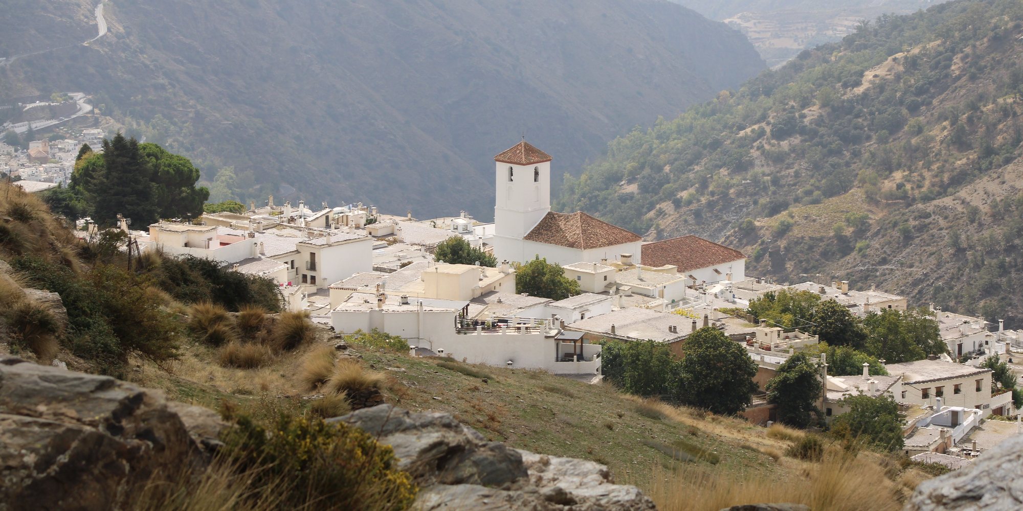
Capileira's white houses and church tower on a slope of the Poqueira gorge, with the valley falling away to the south between dry mountain sides
The village from the slope above · the Poqueira gorge falls away to the south
Town brief · 36.9613°N 3.3599°W

Capileira

Sleep in Capileira and you get what a day trip from Granada never can: the gorge paths to yourself at eight in the morning, before the heat, and in summer a seat on the national park minibus that starts you high on the slopes of Mulhacén.

View on globe

Why you should go

Ninety seconds on Capileira

How long
Two nightsone for the gorge circuit, one for Mulhacén or the drive east
Getting around
On foot, a car for the valleyno private cars beyond the village
When
June to Octoberthe Mulhacén minibus runs in summer only
Language
SpanishEnglish is spoken in hotels, less in bars and shops
Money
The eurocards in hotels; small bars prefer cash
Airports
Granada GRXabout 90 km, an hour and a half by road; Málaga AGP about two hours
How long

How many days do you need in Capileira?

Two nights suit most walkers: one day for the circuit of the three gorge villages, and one for Mulhacén in summer or for the drive to Trevélez and La Taha. A single night covers the village and the short walk down to the river.

Getting around

How do you get around Capileira?

On foot within the village and the gorge, where marked paths link Capileira, Bubión and Pampaneira. A car is the practical way to reach Trevélez and the villages to the east. Private cars cannot drive on from the village into the national park, so the summer minibus is the way up the mountain.

When

When is the best time to visit Capileira?

June to October for the high mountain, when the minibus runs and the summit route is usually clear of snow. Spring and autumn suit the lower walks in the gorge, out of the summer heat. In winter the peaks above the village are under snow.

Language

What language is spoken in Capileira?

Spanish, with a soft Andalusian accent. English is spoken in most hotels and at the walking outfitters, and less in the bars and village shops.

Money

What money does Capileira use?

The euro. Cards are taken in hotels and most restaurants, but small bars and shops prefer cash.

Airports

Where do you fly into for Capileira?

Granada GRX, about 90 km away by road, roughly an hour and a half by car. Málaga AGP is about two hours away by road and has far more flights.

Start walking early. The gorge opens to the south and its paths lose their shade by late morning in summer, so set out by eight and be back for lunch. Storms in early 2026 badly damaged the paths around the Poqueira and many are still closed, so ask at the national park information point which routes are open before you go.

The Mulhacén minibus runs daily in summer and on some spring and autumn weekends, and its seats go fast: book by phone once your dates are fixed, because summer weekends fill about two weeks ahead. It leaves from the information point at the top of the village. Pack a warm layer, a hat and plenty of water, since the summit is cold and windy even when the village bakes.

Drive if you can. Three buses a day leave Granada for the villages and take well over two hours, and the same bus is the only public transport between the villages. Leave the car in the free car park at the entrance to the village; the lanes above it are for walking.

Sleep up here rather than in Pampaneira: Capileira is nearer the trailheads and quieter once the tour coaches turn back in the afternoon. Many bars serve a free tapa with each drink, so two or three rounds make a supper. Nights are cool even in August at this height, so bring a jumper for a terrace dinner.

Give a spare day to the villages east of the gorge. Pitres and the hamlets of La Taha are a walk over the ridge, the iron-red Fuente Agria spring sits by the road at Pórtugos, and Trevélez, with its ham-curing houses, is about 35 minutes further east by car.

Things to do

11
  1. Canyon

    Barranco de Poqueira

    Canyon · 3 hr

    A deep valley under the Sierra Nevada holding three white villages, Capileira at the top and Bubión and Pampaneira below. The marked circuit links all three in about 3 hours and 9.5 km, down one side and back up the other past terraced fields and old irrigation channels. Storms in early 2026 badly damaged the paths here and many are still closed; the national park information point has the current state of each.

  2. Village

    Bubión

    Village · 2 hr

    The middle village of the gorge, about 2 km down a footpath from Capileira and quieter than either neighbour. Its lanes are mostly free of traffic, and the Casa Alpujarreña museum shows a furnished village house as it was lived in. Weaving workshops still make the striped Alpujarra rugs, and the upper paths look out over the valley at sunset.

  3. Museum

    Casa Museo Pedro Antonio de Alarcón

    Museum · 30 min

    A village house a few steps from the church, kept as a folk museum and named for the nineteenth-century writer who travelled the Alpujarras and wrote about them. Its rooms show the tools, looms, kitchen and farm gear of mountain life under beamed ceilings. It is small and takes under an hour, and its opening hours are short and change through the year.

  4. Church

    Church of Nuestra Señora de la Cabeza

    Church · 30 min

    The parish church at the centre of the village, with a gilded Baroque altarpiece and the image of the Virgen de la Cabeza, the village's patron. The bell tower holds a small museum of old bell yokes and parish records. The square in front is where the village gathers for its two fiestas, at the end of April and in mid August.

  5. Landmark

    Fuente Agria de Pórtugos

    Landmark · 30 min

    A spring of naturally fizzy, iron-rich water beside the road to Trevélez, just outside Pórtugos, where the water runs from spouts into a basin stained rust red. Below it, a short flight of steps drops to a small waterfall over rock coloured by the same iron. It makes an easy stop on the drive east to Trevélez.

  6. Village

    La Taha

    Village · 4 hr

    Seven small hamlets, Pitres and Ferreirola among them, in a terraced valley east of the gorge, linked by old mule paths through chestnut and walnut trees. An easy path climbs over the ridge from Capileira and down to Pitres in a little over two hours. Buses on the Trevélez line pass through Pitres for the ride back.

  7. Viewpoint

    Mirador Barranco Poqueira

    Viewpoint

    A lookout on Calle Mentidero, a short walk from the church, over the drop into the Poqueira gorge. Bubión and Pampaneira sit on the slope below, and the valley runs south towards the Contraviesa hills. It faces west across the gorge, so it catches the evening light, and the lanes around it stay quiet even in August.

  8. Other

    Mulhacén

    Other · 8 hr

    At 3,479 metres the highest peak on the Spanish mainland: a long, high walk that needs no climbing skills but is open to wind and sun, with no water on the way. A national park minibus runs from the village in summer to the Paraje del Cascajar at about 2,600 metres, and seats must be booked ahead. The round trip takes most of a day, and the summit is cold and windy even in July.

  9. Village

    Pampaneira

    Village · 2 hr

    The lowest and busiest of the three Poqueira villages, where the tour coaches stop and craft shops sell rugs, ceramics and local produce. The national park information point on the Plaza de la Libertad has maps and the current state of the mountain paths. The gorge circuit passes through the village, which makes it the natural halfway stop on the walk.

  10. Bridge

    Puente Abuchite

    Bridge · 1.5 hr

    A small footbridge over the Poqueira river below Capileira, on the path that drops from the village towards La Cebadilla. The round trip from the main square takes about an hour and a quarter, with a steep climb back up at the end. The river runs cold and fast with snowmelt into early summer, and the path is shaded by chestnut and poplar on the lower slopes.

  11. Village

    Trevélez

    Village · 3 hr

    A mountain village of three barrios stepped up a steep slope, known across Spain for its cured ham. The cold, dry air finishes the hams in curing houses, and several of these drying rooms open for visits and tastings. The village is about 35 minutes east of Capileira on a winding road, and walks to the Siete Lagunas lakes start from its upper barrio.
Basemap Meridian · data © OpenStreetMap
Explore

More of Spain

Spain
Country

Spain

Every Spain town, place and dispatch, on one map.

Granada
Town

Granada

Alhambra
Palace · Granada

Alhambra

Málaga
Town

Málaga

Museo Picasso Málaga
Museum · Málaga

Museo Picasso Málaga

Last updated

Meridian Dispatch for iPhone

Plan the trip.
Keep the journal.

Every other travel app asks you to start logging. Meridian Dispatch opens with years of your travel already written, from the photographs you already took.